Water Department
The Owens Valley Monitor 1999-2000

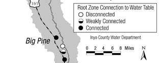


Figure 5: Soil water/root zone
connection at permanent monitoring sites.
Soil Water Conditions
Aaron Steinwand,
Soil Scientist/Science Coordinator
Under the Inyo/Los Angeles Water Agreement, groundwater pumping and subsequent water table decline and recovery is managed by monitoring the soil-plant water balance. Each month, ICWD visits 33 monitoring sites (including eight control sites located away from groundwater pumps) to measure depth to groundwater and soil water content to determine the on/off status of LADWP pumping wells. If the available soil water on July 1 or October 1 is less than the predicted amount of water required by the vegetation, pumping wells linked to the monitoring site must be turned off. The linked wells can be turned on when soil water exceeds the expected plant water requirement at the time wells were turned off.
The on/off determination is affected by several factors, including predicted plant water requirements, estimated drought tolerance of the plant species, soil properties, depth of the root zone monitored, and the amount of precipitation and groundwater added to the soil. Because the relative importance of these factors on the soil-plant water balance can vary greatly, wells may be in "on" status even though no groundwater is reaching the root zone. Conversely, a site may be in "off" status if the water table occurs just below the root zone.
The plant communities that we monitor require periodic connection to the groundwater for long-term survival and recovery from drought. Unfortunately, the on/off status often is not an accurate indicator of whether groundwater is reaching the plant root zone, but the rise of water above the water table due to capillarity is detected easily by the monitoring. Using the soil water and groundwater data, we determine which monitoring sites are connected with the water table and which still need water table recovery. From these observations, possible reasons for the vegetation conditions at a particular site can be identified and the ICWD can then suggest appropriate pumping management under the Drought Recovery Policy, which calls for conservative management of pumping to promote recovery of soil water, water tables, and vegetation.
For simplicity, the 33 monitoring sites are grouped into three categories to summarize the root zone and groundwater connection. The water table depth necessary to provide water to the root zone is not only related to depth-to-water, but it also depends on the rooting depth and soil characteristics. For example, in similar soils, a shallower water table is necessary to supply groundwater to grass-dominated sites than shrub-dominated sites because of the shallower roots of the grasses. Similarly, the capillary rise above the water table in a silty soil is much greater than in a sandy soil thereby allowing plants access to groundwater from greater depths.
Brief descriptions of the three categories are given below. For management purposes, grass-dominated sites are assigned a root zone of 2 meters; shrub sites are assigned a 4-meter root zone. The three categories are:
- Disconnected: No groundwater is reaching the root zone. Five sites occur in this category.
- Weakly connected: Groundwater reaches the bottom 0.5 meters of the root zone. Six sites occur in this category.
- Connected: Groundwater extends to the middle of the root zone, or retained soil water from earlier groundwater recovery is present in the middle of the root zone. Fourteen wellfield sites and all eight control sites occur in this category.
Reduced pumping and recent high runoff years have promoted substantial water table and soil water recovery from the decline induced by high pumping from 1987-1989 at the onset of the six-year drought. During 1999, however, water table recovery slowed or the water table declined slightly because runoff was less than in previous years and because water tables at several sites approached shallow depths reminiscent of pre-drought levels. As a result, the number and locations of sites in each category remained similar to 1998.
As of April 1, 2000, the water table was supplying water to the root zone at 20 of the 25 monitoring sites located in wellfields (Figure 5). This compares to about six sites with groundwater in the root zone near the end of the drought in 1992. The five sites still not connected with groundwater are located in the Taboose-Aberdeen wellfield (1), the Thibaut-Sawmill wellfield (1), southeast of Big Pine (1), and south of Independence (2). Water tables in areas outside the wellfields were little affected by pumping and drought, and the root zones at monitoring sites in these areas remained connected to the water table during the drought.
Return to the Table of Contents
![]()